 Your new post is loading...

|
Scooped by
DocBiodiv
|
Highlights Biological invasions in urban areas resulted in a total cost of US$ 326.7 billion. Urban costs represent ∼15 % of the total costs caused by invasive species. Most of these costs were attributed to damage by insects and impacted mostly public and social welfare. 73 countries have reports of costly invasive species in urban areas, yet no monetary costs have been reported. Taxonomic and geographic gaps can be mitigated with more studies and accurate cost reporting.
|
|
Scooped by
DocBiodiv
|
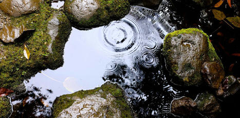
La géophonie rassemble les sons issus des quatre éléments d’Empédocle : la terre, l’eau, le feu et le vent.
|
|
Scooped by
DocBiodiv
|
Species distribution models (SDMs) are statistical tools that relate species observations to environmental conditions to retrieve ecological niches and predict species' potential geographic distributions. The quality and robustness of SDMs clearly depend on good modelling practices including ascertaining the ecological relevance of predictors for the studied species and choosing an appropriate spatial resolution (or ‘grain size').
|
|
Scooped by
DocBiodiv
|
Au sommaire notamment : .A bird in the hand: Global-scale morphological trait datasets open new frontiers of ecology, evolution and ecosystem science. Joseph A. Tobias .AVONET: morphological, ecological and geographical data for all birds .Global biogeographic patterns of avian morphological diversity Emma C. Hughes .Sex roles in birds: Phylogenetic analyses of the influence of climate, life histories and social environment. Alejandro Gonzalez-Voyer
|
|
Scooped by
DocBiodiv
|
Les indicateurs sont organisés selon les 6 critères de gestion durable des forêts européennes, dits critères d'Helsinki - du nom de la conférence où ces critères ont été adoptés.
|
|
Scooped by
DocBiodiv
|
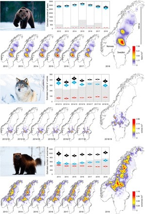
The recent recovery of large carnivores in Europe has been explained as resulting from a decrease in human persecution driven by widespread rural land abandonment, paralleled by forest cover increase and the consequent increase in availability of shelter and prey. We investigated whether land cover and human population density changes are related to the relative probability of occurrence of three European large carnivores: the grey wolf (Canis lupus), the Eurasian lynx (Lynx lynx) and the brown bear (Ursus arctos).
|
|
Scooped by
DocBiodiv
|
The ongoing recovery of terrestrial large carnivores in North America and Europe is accompanied by intense controversy. On the one hand, reestablishment of large carnivores entails a recovery of their most important ecological role, predation. On the other hand, societies are struggling to relearn how to live with apex predators that kill livestock, compete for game species, and occasionally injure or kill people. Those responsible for managing these species and mitigating conflict often lack fundamental information due to a long-standing challenge in ecology: How do we draw robust population-level inferences for elusive animals spread over immense areas? Here we showcase the application of an effective tool for spatially explicit tracking and forecasting of wildlife population dynamics at scales that are relevant to management and conservation.
|
|
Scooped by
DocBiodiv
|
Il a longtemps été supposé que les espèces rares contribuaient faiblement au fonctionnement des écosystèmes. Des études récentes ont cependant remis en cause cette hypothèse, la notion de rareté ne recouvrant pas seulement l’abondance ou l'étendue géographique des espèces, mais aussi l’originalité de leurs rôles écologiques. Ces espèces aux fonctions uniques étant irremplaçables, il est désormais fondamental de comprendre leurs caractéristiques écologiques, de cartographier leur distribution et d’évaluer leur vulnérabilité aux menaces actuelles et futures.
|
|
Scooped by
DocBiodiv
|
Approaches to understanding change in plant function due to climate change often assume a fixed response: a given amount of climate forcing will cause a given amount of change in the measure of interest. Our study shows that this will not be the case for phenology. Effects of warming will be context dependent and vary with natural climate variability. Experimental warming in early, warm springs led to a greater advance of leafing, but more variation among species.
|
|
Scooped by
DocBiodiv
|
Assessing the pathways by which alien species are introduced is essential if we are to identify potential risks and evaluate management decisions. Intentional introductions are responsible for the introductions of millions of animals throughout Latin America. We explore: (1) the relative role of several intentional introduction pathways (hunting, feeding, fur, biological control, the pet trade and others) in the general context of introductions of alien species; (2) the relative importance of the intentional pathways across the different taxa; (3) similar patterns as regards the composition of alien species across countries, (4) the underlying factors that drive the richness of alien species in Latin America, and (5) the potential impacts of alien species on the region. According to our results, 69 species of mammals and 62 species of birds were introduced into Latin America by means of intentional pathways...
|
|
Scooped by
DocBiodiv
|
To understand how functional traits and evolutionary history shape the geographic distribution of plant life on Earth, we need to integrate high‐quality and global‐scale distribution data with functional and phylogenetic information. Large‐scale distribution data for plants are, however, often restricted to either certain taxonomic groups or geographic regions.
|
|
Scooped by
DocBiodiv
|
How climate affects species distributions is a longstanding question receiving renewed interest owing to the need to predict the impacts of global warming on biodiversity. Is climate change forcing species to live near their critical thermal limits? Are these limits likely to change through natural selection? These and other important questions can be addressed with models relating geographical distributions of species with climate data, but inferences made with these models are highly contingent on non-climatic factors such as biotic interactions.
|
|
Scooped by
DocBiodiv
|
Le Géoportail permet désormais d’accéder à des photographies aériennes en mode infrarouge sur un ensemble de départements. Découvrez leurs usages. La majorité des prises de vues aériennes exploitent la partie visible du spectre de lumière afin d’obtenir des images réalistes au niveau des couleurs. Néanmoins, l’utilisation d’autres parties du spectre lumineux peut être pertinente pour des usages spécifiques. Ainsi, le proche infrarouge permet d’interpréter avec précision des prises de vues dans le cadre de travaux d’inventaire forestier.
|
|
|
Scooped by
DocBiodiv
|
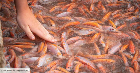
Durant des millions d'années, les poissons d'eau douce évoluaient de manière isolée dans leurs continents respectifs. Jusqu'à ce que le déplacement massif des espèces par les sociétés humaines rebattent les cartes, selon une étude parue vendredi 17 novembre.
|
|
Scooped by
DocBiodiv
|
Area of Habitat (AOH) is “the habitat available to a species, that is, habitat within its range”. It complements a geographic range map for a species by showing potential occupancy and reducing commission errors. AOH maps are produced by subtracting areas considered unsuitable for the species from their range map, using information on each species’ associations with habitat and elevation.
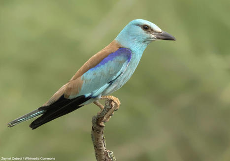
Alors que les températures du mois de juillet 2022 sont très élevées en Europe de l'Ouest et qu'un Rollier d'Europe séjourne depuis au moins le 15 juillet 2022 en Seine-et-Marne (près de Paris), une étude récente suggère que l'espèce devrait connaître une expansion importante en France et en Italie à moyen terme.
Via LPO Île-de-France
|
|
Scooped by
DocBiodiv
|
Primary forests, defined here as forests where the signs of human impacts, if any, are strongly blurred due to decades without forest management, are scarce in Europe and continue to disappear. Despite these losses, we know little about where these forests occur. Here, we present a comprehensive geodatabase and map of Europe’s known primary forests. Our geodatabase harmonizes 48 different, mostly field-based datasets of primary forests, and contains 18,411 individual patches (41.1 Mha) spread across 33 countries. When available, we provide information on each patch (name, location, naturalness, extent and dominant tree species) and the surrounding landscape (biogeographical regions, protection status, potential natural vegetation, current forest extent).
|
|
Scooped by
DocBiodiv
|
Recent declines of many European bird species have been linked with various environmental changes, especially land-use change and climate change. Since the intensity of these environmental changes varies among different countries, we can expect geographic variation in bird population trends. Here, we compared the population trends of bird species among neighbouring countries within central Europe (Czech Republic, Denmark, Germany, Switzerland) between 1990 and 2016 and examined trait-associations with population trends at both national and international scales. We found that Denmark had the highest proportion of declining species while Switzerland had the lowest.
|
|
Scooped by
DocBiodiv
|
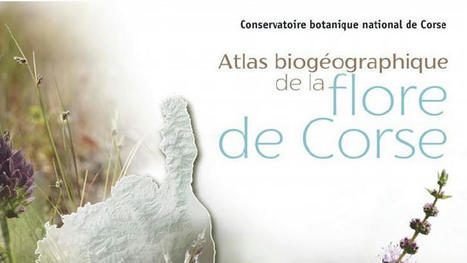
Il y a cent trente-deux espèces de plantes qui ne poussent qu’en Corse. L’Atlas qui est vient de sortir aux éditions Albiana propose une présentation détaillée de 500 des 2300 espèces présentes en corse et notamment de celles qui sont endémiques.
|
|
Scooped by
DocBiodiv
|
Identifying species that are both geographically restricted and functionally distinct, i.e. supporting rare traits and functions, is of prime importance given their risk of extinction and their potential contribution to ecosystem functioning. We use global species distributions and functional traits for birds and mammals to identify the ecologically rare species, understand their characteristics, and identify hotspots.
|
|
Scooped by
DocBiodiv
|
De nombreuses îles ont une forte biodiversité mais sont aussi des épicentres d’extinction. Cette biodiversité étant souvent la seule richesse de ces territoires isolés, mieux la protéger est une priorité pour l’adaptation des systèmes insulaires aux changements environnementaux. En constituant une base de données mondiale pour 2323 îles habitées, des scientifiques, dont une équipe du Centre pour la biodiversité marine, l'exploitation et la conservation (MARBEC), montrent que 50 % de ces îles n’ont aucune aire protégée. Cette absence de protection dépend à la fois du climat, de la diversité culturelle, de la densité humaine et du niveau de développement.
|
|
Scooped by
DocBiodiv
|
Il semble que certains animaux voient leur taille diminuer dans les zones où la température augmente. Stratégie d’adaptation ou conséquence du changement climatique ? De nombreuses espèces sont aujourd’hui en déclin, même si parfois, la vie semble s’adapter : certaines espèces sont capables de décaler leur domaine vital vers les pôles pour y chercher la fraîcheur, d’autres modifient leurs habitudes, et certaines deviennent même… plus petites ! Serait-ce une stratégie pour moins souffrir de la chaleur ou simplement une conséquence subie du changement climatique ? Au cours de ma thèse sur ce sujet, je me suis appuyé sur les théories développées en biogéographie...
|
|
Scooped by
DocBiodiv
|
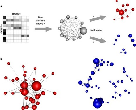
According to the competitive exclusion principle, species with low competitive abilities should be excluded by more efficient competitors; yet, they generally remain as rare species. Here, we describe the positive and negative spatial association networks of 326 disparate assemblages, showing a general organization pattern that simultaneously supports the primacy of competition and the persistence of rare species. Abundant species monopolize negative associations in about 90% of the assemblages. On the other hand, rare species are mostly involved in positive associations, forming small network modules.
|
|
Scooped by
DocBiodiv
|
Le parc national de la Vanoise a entrepris un suivi par localisation GPS de la population des bouquetins des Alpes sur son territoire. Cette année des opérations de capture ont donc été réalisées par les équipes du Parc pour équiper des bouquetins de collier GPS. Ceux-ci vont permettre de mieux connaître les déplacements des animaux et de réaliser un point sanitaire sur les populations du parc national. Cette étude s’inscrit dans le cadre du programme de coopération transfrontalière « ALCOTRA LEMED (du Leman jusqu’à la Méditerranée) IBEX ».
|
|
Scooped by
DocBiodiv
|
«Au début nous arrivions à géolocaliser environ 30 à 50 % des échouages. Pour 2017, nous sommes arrivés à géolocaliser 2 183 oiseaux précisément sur les 2 773 pris en charge soit quasiment 80% des échouages. C'est le résultat des campagnes de sensibilisation menées auprès des acteurs principaux du réseau de sauvetage. Ils ont été sensibilisés sur la nécessité de noter les informations géographiques de l’échouage de l’oiseau», explique la SEOR.
|


Gustavo Heringer, Romina D. Fernandez, Alok Bang, Marion Cordonnier, Franck Courchamp, Science of The Total Environment, Vol 917,2024, https://doi.org/10.1016/j.scitotenv.2024.170336