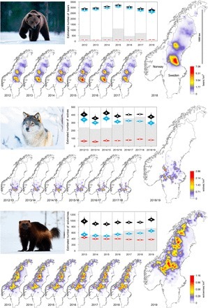
The ongoing recovery of terrestrial large carnivores in North America and Europe is accompanied by intense controversy. On the one hand, reestablishment of large carnivores entails a recovery of their most important ecological role, predation. On the other hand, societies are struggling to relearn how to live with apex predators that kill livestock, compete for game species, and occasionally injure or kill people. Those responsible for managing these species and mitigating conflict often lack fundamental information due to a long-standing challenge in ecology: How do we draw robust population-level inferences for elusive animals spread over immense areas? Here we showcase the application of an effective tool for spatially explicit tracking and forecasting of wildlife population dynamics at scales that are relevant to management and conservation.


 Your new post is loading...


![[Projet Cartographie milieux humides] Publication du jeu de données « terrain » ayant permis de valider la prélocalisation par modélisation | Biodiversité | Scoop.it](https://img.scoop.it/o_zzspQS-65Vn-FWNC-M_Tl72eJkfbmt4t8yenImKBVvK0kTmF0xjctABnaLJIm9)


GEO avec AFP Publié le 20/11/2023. Via @BLeroyEcology
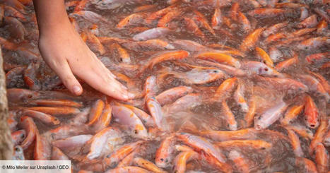
Article de recherche : Boris Leroy et al., Major shifts in biogeographic regions of freshwater fishes as evidence of the Anthropocene epoch. Sci. Adv.9, eadi5502(2023) .DOI:10.1126/sciadv.adi5502
Lire aussi sur le site The Conversation France par Boris Leroy
Maître de conférences en écologie et biogéographie (MNHN)
: La répartition géographique des poissons d’eau douce, nouveau marqueur de l’anthropocène ?