Biodiversité
143.9K views | +33 today
Follow
Biodiversité
Revue de presse et du net par le Pôle de partage des connaissances S&T de l'Office français de la biodiversité
Curated by DocBiodiv
Your new post is loading...
Scooped by DocBiodiv
Scoop.it!

Premiers résultats pour la campagne de recensement de la mégafaune marine en Atlantique nord-est SCANS-IV

Premiers résultats pour la campagne de recensement de la mégafaune marine en Atlantique nord-est SCANS-IV | Biodiversité | Scoop.it

Sur près de 15 000 kilomètres parcourus, plus de 1000 observations de mammifères marins ont été effectuées. Depuis 1994, les campagnes SCANS (Small Cetaceans in European Atlantic waters and the North Sea) ont pour objectifs d’évaluer l’abondance et la répartition des mammifères marins, mais aussi des oiseaux, tortues, grands poissons et déchets en mer. Elles sont réalisées tous les six ans pour évaluer l’état écologique de ces populations.

DocBiodiv's insight:

En savoir plus, carnet de bord de la campagne https://storymaps.arcgis.com/stories/90250af8d1ff48be9a8a40ec63a8476c

No comment yet.
Scooped by DocBiodiv
Scoop.it!

An Evaluation of Systematic Versus Strategically-Placed Camera Traps for Monitoring Feral Cats in New Zealand

An Evaluation of Systematic Versus Strategically-Placed Camera Traps for Monitoring Feral Cats in New Zealand | Biodiversité | Scoop.it

We deploy camera traps to monitor feral cat (Felis catus) populations at two pastoral sites in Hawke’s Bay, North Island, New Zealand. At Site 1, cameras are deployed at pre-determined GPS points on a 500-m grid, and at Site 2, cameras are strategically deployed with a bias towards forest and forest margin habitat where possible. A portion of cameras are also deployed in open farmland habitat and mixed scrub. We then use the abundance-induced heterogeneity Royle–Nichols model to estimate mean animal abundance and detection probabilities for cameras in each habitat type. Model selection suggests that only cat abundance varies by habitat type. 

DocBiodiv's insight:

Sur la méthodo d'usage des pièges photographiques pour le suivi de l'espèce via @AS_Glen  @Vidal_Eric_isld

 
No comment yet.
Scooped by DocBiodiv
Scoop.it!

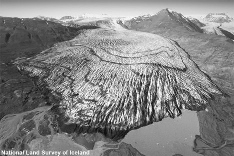
Images reveal Iceland's glacier melt

Images reveal Iceland's glacier melt | Biodiversité | Scoop.it

A photography project has highlighted the extent of ice loss from Iceland’s largest glaciers.  A team from Scotland and Iceland compared photographs taken in the 1980s with present-day drone images. They focused on the south side of the Vatnajökull ice cap, which covers about 7,700sq km of land.

Dr Kieran Baxter, from the University of Dundee, said: "We saw a staggering difference in a very short amount of time."

DocBiodiv's insight:

Voir aussi cet article pour comprendre la méthodo de l'étude et les enjeux technologiques, drones etc : "How to Combine Old Aerial Photos and Modern-day Drone Photography" 02/11/2019 https://www.hydro-international.com/content/news/how-to-combine-old-aerial-photos-and-modern-day-drone-photography

et le compte Twitter @AliceWatterson participant à l'étude.

 
No comment yet.