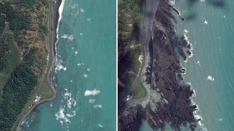
The 7.8 magnitude earthquake that hit New Zealand’s South Island lifted up the seabed by two metres, pushing it above the ocean’s surface.
Via Aki Puustinen
Get Started for FREE
Sign up with Facebook Sign up with X
I don't have a Facebook or a X account


 Your new post is loading...
 Your new post is loading...
Your new post is loading...
The 7.8 magnitude earthquake that hit New Zealand’s South Island lifted up the seabed by two metres, pushing it above the ocean’s surface. Via Aki Puustinen 
No comment yet.
Sign up to comment
"A nice flood rolled down Johnson Canyon (southern Utah) on July 6th, 2015."
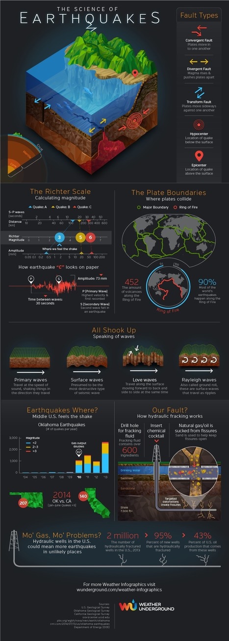
From fault types to the Ring of Fire to hydraulic fracking, the Earthquakes infographic by Weather Underground helps us understand the complexities of what shakes the ground. Tags: disasters, geomorphology, physical, infographic.

GTANSW & ACT's curator insight,
June 1, 2015 2:14 AM
The causes, impacts and responses to a geomorphological hazard

Ness Crouch's curator insight,
July 6, 2015 10:05 PM
Excellent infographic for showing Earthquakes :) 
Jason Nemecek's curator insight,
March 2, 2016 2:00 PM
Australian Curriculum The causes, impacts and responses to a geomorphological hazard (ACHGK053)
GeoWorld 8 Chapter 4: Hazards: causes, impacts and responses (4.5 - 4.6 Earthquakes)

"The edge of the 4,000 square foot residence on Overlook Court was dangling about 75 feet above the rocky shoreline of Lake Whitney after part it it had already broken off."

Massimo Dott. For. Amb. Di Duca's curator insight,
June 15, 2014 12:13 PM
E la prospezione geologica da presentare al Comune? Era prevista nel PRG del comune? Esisteva un VIA? |

"The Humanitarian OpenSteetMap Team (HOT) has activated to provide geographic base data in areas affected by Hurricane Matthew. Category 4 Hurricane Matthew continues to strengthen and is advancing on Haiti and the Bahamas. Hurricane Matthew is expected to cause 'catastrophic' damage including extreme flooding and landslides potentially affecting millions in Haiti, Jamaica, and Bahamas. To start we are mapping coastal communities in the storm path."
From
www


Richard Aitchison's curator insight,
March 22, 2018 11:09 AM
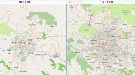
This is a great example of how using technology can benefit people. In Nepal, in which they are an area where they can get many earthquakes, they used "crisis maps" to their advantage. First off as the article state Nepal is a very difficult country to navigate and especially after the earthquake with roads being destroyed it could make it nearly impossible. With people in dire need of supplies they had to get creative. So here they used a software system called "OpenStreetMap." It is, as described in the article, a Wikipedia for mapmakers. Basically, anyone can add to the map from an amateur to a professional map maker. By allowing everyone to help they were able to make more accurate maps and faster ways to reach someone that had a need for supplies, these became the crisis maps that they would use. Going into the future this software will continue to be important in Nepal as you can constantly edit the maps and continue to find better and more efficient ways to get to place to place. Other countries with these issues should look towards Nepal and take preemptive action so that when a disaster does strike they will be ready and will not lose valuable time right after a disaster. A very interesting article in which I did not previously know much about.

"Mount Tavurvur, on Papua New Guinea's New Britain Island, erupted on August 29, 2014, throwing ash (gray-brown areas of September image) over surrounding areas. Its last major eruption was in 1994. Tavurvur is a stratovolcano, a volcano consisting of alternating layers of lava and ash, and is located along the eastern edge of the Rabaul Volcanic Complex. Simpson Harbor forms part of the much larger (mostly submerged) Rabaul Caldera." Tags: disasters, remote sensing, Oceania, Papua New Guinea, physical.

Danielle Lip's curator insight,
April 22, 2015 9:16 PM
There may not be may words on this article but a picture can speak a thousands words as I've seen when looking at these pictures. The climate changing is not only affecting the way people live but it is also affecting the structure of the world's atmosphere such as the melting glacier in Peru called Qori Kalis. The ice and glacier has retreated so much that the ice has melted and created a small lake right in the middle where the huge glacier used to stand. What is going to happen to the work if these type of disasters keep occurring? What other types of physical changes will occur? Any type of change in the land can affect how people live, how they find shelter and any other aspect of living. These type of physical changes are not only happening far from the United States but also in the United States such as California. It is important to look at these 302 photos because it really put life into perspective, showing how something can easily change over time. |